GPS Camera
- للاندرويد 4.1
- الاصدار: 6.2.7
- 15 MB
تحميل
قم بالتحديث لأحدث نسخة 6.2.7!
| app اسم | GPS Camera |
|---|---|
| الاصدار | 6.2.7 |
| المطور | KD SOFT LTD |
| يتطلب نسخة اندرويد | للاندرويد 4.1 |
| أخر تحديث | 2024-04-22 |
تحميل GPS Camera app للاندرويد
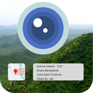
Caption: The main features this app you can add your own caption with image like who take image him/her name or any other caption you add in setting page.
Geotagging: The app automatically embeds GPS coordinates into the photos you take, so you'll always know where each picture was taken. This is useful for organizing and recalling memories based on location.
Documentation: If you're in a profession or hobby where documenting locations is important, such as real estate, travel blogging, or field research, the app can help you accurately record where each photo was taken.
Navigation: Some apps allow you to overlay maps onto your photos, providing visual context for where you were when the picture was taken. This can be helpful for navigation or sharing detailed location information with others.
Memory Aid: Sometimes, we take photos and forget exactly where they were taken. The GPS Map Camera app eliminates this problem by automatically recording location data with each photo.
Social Sharing: When sharing photos on social media, having the location embedded can enhance the story you're telling. Whether it's a beautiful landscape, a delicious meal, or a memorable event, knowing the location adds context for your audience.
Travelogue: For travelers, the app can serve as a digital travelogue, documenting each stop along the journey with precise location data attached to each photo
GPS Maps:
GPS, or Global Positioning System, is a satellite-based navigation system that enables users to determine their precise location and navigate from one point to another. GPS maps are digital representations of geographical areas that can be displayed on electronic devices such as smartphones, tablets, or dedicated GPS devices. These maps provide information about roads, landmarks, points of interest, and other relevant details, helping users plan routes, get directions, and track their movements.
Key features of GPS maps include real-time tracking, turn-by-turn navigation, traffic updates, and the ability to search for specific locations or businesses. Many GPS map applications also offer offline maps, making navigation possible even in areas with limited or no internet connectivity.
Font & Back Camera:
A camera is a device used to capture still or moving images. In the context of mobile devices, it typically refers to the built-in camera in smartphones or dedicated digital cameras. Cameras have become integral components of modern devices, allowing users to capture memories, document events, and share experiences through photos and videos.
Key features of cameras can include high-resolution sensors, optical zoom capabilities, image stabilization, various shooting modes, and advanced settings for manual control. In the case of smartphones, cameras often serve multiple purposes, such as scanning QR codes, augmented reality applications, and, potentially, integration with GPS for geotagging photos.
Integrated GPS Maps Camera:
If you're referring to a device that combines both GPS maps and a camera, it could be a smartphone or a specialized camera with GPS capabilities. In such a device, the GPS functionality would be used to provide location-based services, while the camera would capture visual information.
This combination is particularly useful for geotagging photos, where the GPS coordinates of the location where a photo was taken are embedded in the image's metadata. This feature allows users to organize and share photos based on their geographic location.
4.3 (36)
معلومات إضافية من جوجل بلاي:
- أخر تحديث
- السعر$0
- عدد التحميلات 5,000+
- الفئة العمرية 12+ سنة
سرعة عالية و بدون فيروسات!
تم اختبار الروابط من قبلنا وهى سريعه وأمنه للتحميل!