GPS Photo Location on Map
- Android 4.1
- Version: 1.3
- 38 MB
Download
Updated to version 1.3!
| app Name | GPS Photo Location on Map |
|---|---|
| Version | 1.3 |
| Developer | Dev Lab Studio |
| OS | Android 4.1 |
| Updated | 2024-04-23 |
Download GPS Photo Location on Map app Android
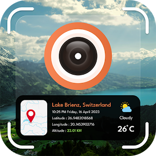
GPS Photo Location on Map is a user-friendly app designed to enhance your photo-sharing experience by adding any current location information to your images. With GPS Photo Location on Map, you can effortlessly capture memories with location tags in a map view. Now you can capture all your memories with a live location tag by using this GPS Photo Location on the Map App. The app allows users to set a location with their current address and latitude and longitude details.
GPS Photo Location on Map has multiple templates with which you can capture every image with a different tag view. Pick one of your choices from the collection and capture the moments with this beautiful location tag. This GPS Photo Location on Map app also allows the option to add location details to an existing image, select from the gallery, and add a location tag to the image. The app also allows users to view images location-wise. Save all your captured images and videos in the app gallery.
Key Features:
The best way to pinpoint the location where your photos and videos were captured
The app offers a map view feature where you can see the location map view
app automatically organizes your photos based on their location
It is easy to save the photos and videos into the app gallery
You can save live location details with the Set location tool
Multiple templates are available
Option to add location details in your existing gallery images
4 (562727)
Additional Information:
- Updated
- Price$0
- Installs 1,000+
- Rated for 12+ years
Good speed and no viruses!
On our site you can easily download All Apps And Games without registration and send SMS!