GPS Photo With Map Location
- Android 4.1
- Version: 1.0
- 13 MB
Download
Updated to version 1.0!
| app Name | GPS Photo With Map Location |
|---|---|
| Version | 1.0 |
| Developer | RMOT DEVELOPER |
| OS | Android 4.1 |
| Updated | 2024-03-16 |
Download GPS Photo With Map Location app Android
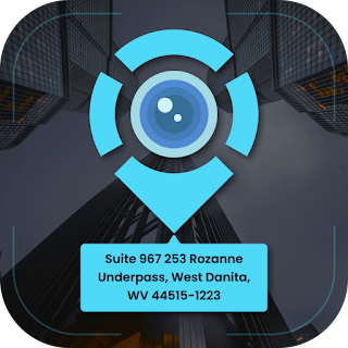
GPS Photo with Map Location is a smart application that integrates GPS location data with photos, allowing the user to capture an image with geographic information such as coordinates, altitude and address.
This application is easy to get GPS location and GPS coordinates on your captured photo according to your current location.
Have you ever forgotten a location and location in a photo?
GPS Photo with Map Location application can solve this problem. Click a photo from the camera and your current location will be visible in that photo.
If you are traveling somewhere or going to a particular place, then you can click your photo with the help of this app and see the current address, date, time and latitude and longitude of the map in that photo. You can also add accurate weather, magnetic fields and wind to your photos. You can save your photo in your photo gallery.
Track the current location and weather forecast from your photos captured by a GPS Photo with Map Location, send your geo-location of road/place to your family and friends through photos, and tell them about your best Earth travel memories.
In this app feature, you can choose an advanced template and a classic template to add your GPS location to your photo and you can set the map data automatically or manually.
Main Feature:
Easy to use.
Get location stamps on photos while capturing.
Automatically embeds GPS location data in photos, including latitude, longitude, altitude, and address information.
Set map data automatic or manual.
Classic template contains automatically fetched geo-logical map details.
Change map type from normal, satellite, terrain, hybrid options.
Address: Add your selected manual/automatic current location on image.
Add date and time in various formats with other geographical map data.
Measure temperature units and get live and accurate weather data on photos
It will automatically calculate the altitude of elevation.
To add Address, Latitude Longitude, GPS Coordinates, Date-Time and Weather.
Make use of the GPS Photo with Map Location anytime anywhere.
Photos can be easily shared with friends
5 (10)
Additional Information:
- Updated
- Price$0
- Installs 500+
- Rated for 12+ years
Good speed and no viruses!
On our site you can easily download All Apps And Games without registration and send SMS!