Spotlens - GPS Camera for work

- Android 6.0
- Version: 1.2.02
- Varies with device
Download
Updated to version 1.2.02!
| app Name | Spotlens - GPS Camera for work |
|---|---|
| Version | 1.2.02 |
| Developer | Kostner |
| OS | Android 6.0 |
| Updated | 2024-05-17 |

Download Spotlens - GPS Camera for work app Android
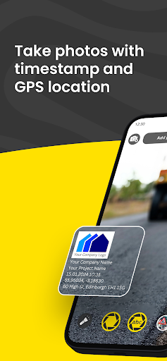
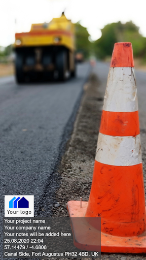
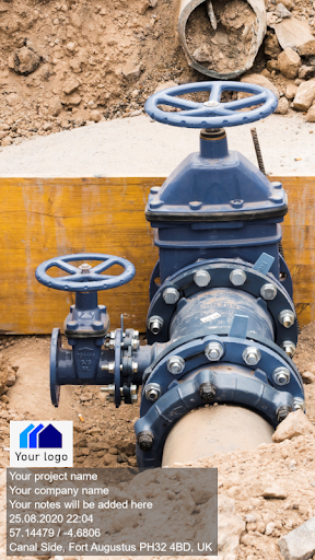
Conota (formerly Spotlens) is the ideal camera app for work. It has been developed particularly for professionals like civil engineers, land surveyors, architects, construction professionals and other professionals. The app allows to take photos on site and simultaneously add information both to the file name and to the photo with use of a watermark.
Conota - GPS Camera & Timestamp Camera makes capturing pictures and taking notes more efficiently, combining both processes in one single app.
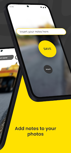
There is no need to take notes on a piece of paper while taking pictures. Conota will add your inserted notes automatically both to the picture and to the file name. This will give you more time to concentrate on your work, while Conota will take care of saving your notes and pictures combined in a lossless format onto your phone.
Conota works, so you can work!
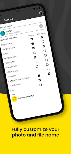
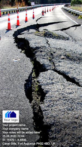
With Conota - GPS Camera & Timestamp Camera, you can add a project name, company name, notes and more information, for example a reference no. or chainage directly in the app while taking pictures.
Additional relevant data for professionals, e.g. GPS coordinates / photo location (latitude and longitude and multiple other coordinate formats), GPS accuracy, altitude, address, date and time (timestamp) will be added by Conota.
Information that can be added:
- Project name
- Taken notes
- GPS coordinates / photo location (latitude and longitude & more)
- GPS accuracy (in m or ft)
- Altitude (in m or ft)
- Date & time (timestamp)
- Address
- Compass direction
- Customized company logo
- Reference No. / Chainage
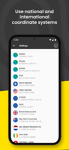
Conota - GPS Camera & Timestamp Camera supports the following coordinate/grid systems:
- WGS84 (latitude and longitude)
- UTM
- MGRS (NAD83)
- USNG (NAD83)
- State Plane Coordinate System (NAD83 - sft)
- State Plane Coordinate System (NAD83 - ift)
- ETRS89
- ED50
- British National Grid (OS National Grid)
- Map Grid of Australia (MGA2020)
- RD (RDNAPTRANS2018)
- Irish Grid
- Swiss Grid CH1903+ / LV95
- New Zealand Transverse Mercator 2000 (NZTM2000)
- Gauß-Krüger (MGI)
- Bundesmeldenetz (MGI)
- Gauß-Krüger (Germany)
- SWEREF99 TM
- MAGNA-SIRGAS / Origen-Nacional
- SIRGAS 2000
- CTRM05 / CR05
- PRS92
- PT-TM06 / ETRS89
- STEREO70 / Pulkovo 1942(58)
- HTRS96 / TM
Conota - GPS Camera & Timestamp Camera is used by land surveyors, civil engineers, construction managers, architects, geologists, real estate agents, and other professionals world-wide. Become one of them!
Conota - GPS Camera & Timestamp Camera makes capturing pictures and taking notes more efficiently, combining both processes in one single app.
There is no need to take notes on a piece of paper while taking pictures. Conota will add your inserted notes automatically both to the picture and to the file name. This will give you more time to concentrate on your work, while Conota will take care of saving your notes and pictures combined in a lossless format onto your phone.
Conota works, so you can work!
With Conota - GPS Camera & Timestamp Camera, you can add a project name, company name, notes and more information, for example a reference no. or chainage directly in the app while taking pictures.
Additional relevant data for professionals, e.g. GPS coordinates / photo location (latitude and longitude and multiple other coordinate formats), GPS accuracy, altitude, address, date and time (timestamp) will be added by Conota.
Information that can be added:
- Project name
- Taken notes
- GPS coordinates / photo location (latitude and longitude & more)
- GPS accuracy (in m or ft)
- Altitude (in m or ft)
- Date & time (timestamp)
- Address
- Compass direction
- Customized company logo
- Reference No. / Chainage
Conota - GPS Camera & Timestamp Camera supports the following coordinate/grid systems:
- WGS84 (latitude and longitude)
- UTM
- MGRS (NAD83)
- USNG (NAD83)
- State Plane Coordinate System (NAD83 - sft)
- State Plane Coordinate System (NAD83 - ift)
- ETRS89
- ED50
- British National Grid (OS National Grid)
- Map Grid of Australia (MGA2020)
- RD (RDNAPTRANS2018)
- Irish Grid
- Swiss Grid CH1903+ / LV95
- New Zealand Transverse Mercator 2000 (NZTM2000)
- Gauß-Krüger (MGI)
- Bundesmeldenetz (MGI)
- Gauß-Krüger (Germany)
- SWEREF99 TM
- MAGNA-SIRGAS / Origen-Nacional
- SIRGAS 2000
- CTRM05 / CR05
- PRS92
- PT-TM06 / ETRS89
- STEREO70 / Pulkovo 1942(58)
- HTRS96 / TM
Conota - GPS Camera & Timestamp Camera is used by land surveyors, civil engineers, construction managers, architects, geologists, real estate agents, and other professionals world-wide. Become one of them!
4.3 (21346)
Additional Information:
- Updated
- Price$0
- Installs 1,000,000+
- Rated for 12+ years
Good speed and no viruses!
On our site you can easily download All Apps And Games without registration and send SMS!