Picture GPS: Location On Photo
- Android 4.1
- Version: 30.0
- 15 MB
Download
Updated to version 30.0!
| app Name | Picture GPS: Location On Photo |
|---|---|
| Version | 30.0 |
| Developer | Carpenter Apps |
| OS | Android 4.1 |
| Updated | 2024-03-08 |
Download Picture GPS: Location On Photo app Android
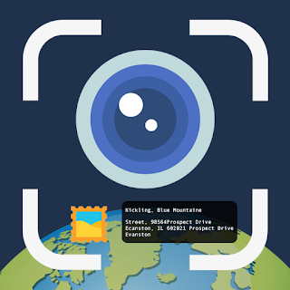
Install Picture GPS: Location On Photo App to add location to photos app & Send your geo-location of place through photos to your family & friends, and let them know about your best earth travel memories.Track your current GPS Location, Click Photo, save it and share With your loved one. The Geo tag Photos is used for Add GPS Location,Latitude Longitude, Altitude, GPS Coordinates, DateTime on photo. Find the elevation of location automatically with your camera and stamp on your pictures.
App Users can use defualt provided folders for different types of photo collections as well as He/she can make unlimited folders as per his/her choice so that he/she can categorized their photos in good manners. User can change Template by his/her own choice. The Users can set many options to template like Wind, Location,Latitude Longitude, Altitude, Note, Date and Time, Time zone, Logo, Weather, Campass, Magnetic field, Humidity, Pressure, Accuracy. Also User can change stamp location like Top,bottom. User can Change Font style. For use these all totally free features, install GPS Map Camera App today only.
Picture GPS: Location On Photo - Geotag photos Location app is best suitable for:
- Travelers and explorers
- On-field working agents who needs to share their location to his/her boss
- Land Measurement team
- Internet provider team member who is working on field
- kyc verification team
- Area survey team
- Person in the real estate and architecture industries can add a GPS Map Location stamp to their Site Images.
- Travel, Fashion, Art And Food Bloggers may use the GPS Map Camera to add GPS Location, Date & Time on Photos.
If you are person like above mentioned, you should have GSP Map Camera (Geotag photos) App in your phone to make your work easy and simple.
Main Features of GPS Map Camera:
* Add GPS Stamp to Your Photos
* When you want Location on Photo you can get gps camera in your phone
* To attached Date Time on phone
* To set Full Address Pin on Photos
* To put my current location on the photo
* To add Latitude Longitude, Altitude, GPS Coordinates, DateTime, Compass to Photo
* To have Geotag Photos with an easy GPS location tracker
* Make use of the Camera GPS stamp free anytime anywhere
* Let's click pictures everywhere with a Map stamp on it with GPS Map Camera
* Take Clear Pictures Anywhere with Our Map Camera
App With new invented feature is Gps Area Calculator so now you can use gps area calculator for calculation area in phone.
The GPS area calculator app uses advanced measuring features to provide you with instant and accurate measurements of land areas, making it the perfect solution for buyers, sellers, and anyone else who needs to measure land. Plus, this app is incredibly user-friendly, with a simple interface that anyone can navigate.
GPS fields area calculator features:
- Calculate Area on map in Sq. Meter, Sq. Feet, Hectare, Acre, Guntha
- Fast area/distance Mapping.
- Measurement saving and editing
- Map, Satellite, Terrain and Hybrid modes
We are happy to say that Geotag photo app is first choice of every photographer to get geotag Map stamp details.Do not forget to share your best experiences with us Through Rate & Review.
3.9 (1823)
Additional Information:
- Updated
- Price$0
- Installs 100,000+
- Rated for 12+ years
Good speed and no viruses!
On our site you can easily download All Apps And Games without registration and send SMS!